2 Planning unit reconciliation
2.1 Description
This module can be used to develop rules to resolve conflicting perspectives on land allocation. This module allows modification to the planning unit attribute table and dissolve planning unit per unique ID. Planning unit reconciliation is a process to resolve overlapping permits by referring to function reference maps. Reconciliation is done by analyzing how well the permit data matches the reference data.
2.2 Usage
2.2.1 Workflow
Data Preparation
Unresolved Case Map (Shape file format) Shape file of overlayed planning units with some layer that conflict, defined as unresolved case.
Unresolved Case Attribute (CSV format) Detailed unresolved case table. Before running PUR Reconcile module, the reconcile action (drop-down selection) on ‘PUR_unresolved_case.xlsx’ need to be defined. You can use Microsoft Excel or any free spreadsheet software (e.g. Google Sheet) to do it.
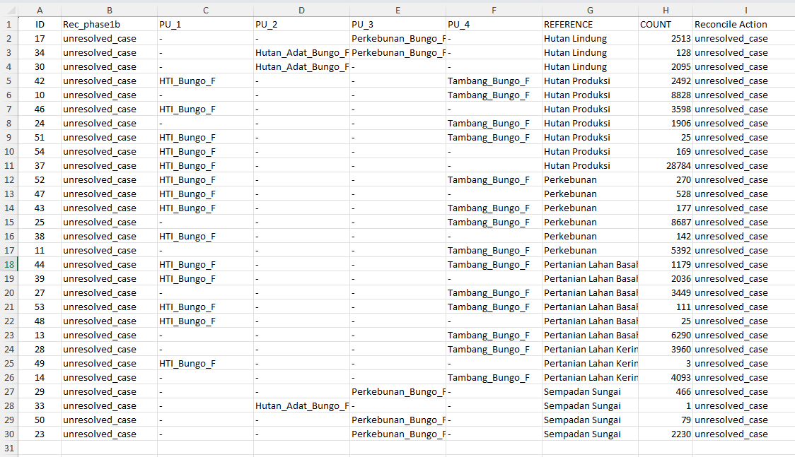
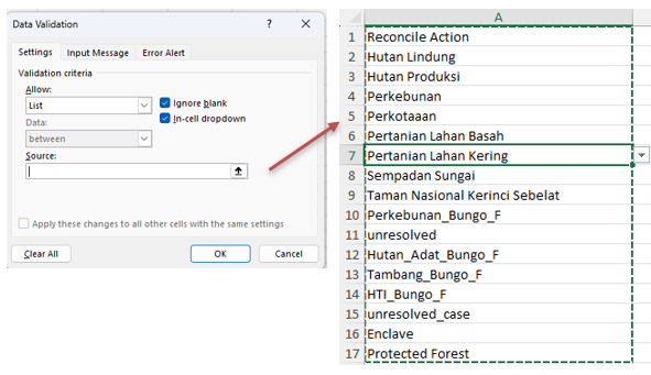
If you want to add a new class on ‘reconcile action’, the steps are:
Unhide the sheet, you will see ‘drop-down_attribute’
Click Data > Data Validation
Source > Block the columns you want to add
Open the ‘PUR_unresolved_case’ sheet, click data validation. Fill in the source the same as written in the ’drop-down_attribute.
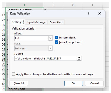
Now you can choose the new class as a reconciliation action.
2.2.2 Step-by step instructions
Step 1: Uploading Data
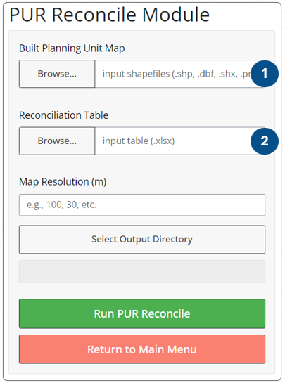
Build planning unit with uploading Unresolved Case Map shapefile Select all related shapefiles (dbf, .prj, .shp, .shx), as shown below

Unresolved Case Attribute Detailed unresolved case table. Please make sure that the reconcile action column is ‘resolved’.
Unresolved attributes table (.xlsx)
Step 3: Running the Analysis - Click the “Run Analysis” button. - A progress bar will appear, indicating the analysis status. - Once complete, the results will be displayed in the “Results” tab.
2.2.3 Tips
Ensure the reconcile action in reconciliation table has been defined.
2.3 Data Requirements
2.3.1 Input Data and Parameters
| No | Data Name | Type | Format | Projection Requirements | Description |
| 1. | Planning Unit map | Shape file | .shp | UTM | This map is the output of PUR Build and contain every reconciled and unresolved case area information. |
| 2. | Reconciliation table | Numerical | CSV | Table shows the area of land that overlapped | Unresolved case per ID |
2.3.2 Example Datasets
Practice data sets used in this module can be accessed at agroforestri.id/lumens-pur
2.3.3 Data Acquistion
2.4 Outputs
2.4.1 Output Files
2.4.2 Report Interpretation
Planning unit reconciliation is a process to resolve overlapping permits by referring to function reference maps. Reconciliation is done by analyzing how well the permit data matches the reference data. Permit data can include things like forest management concessions, plantation permits, mining permits, and others. Reference data can be spatial planning data or area designation data.
By analyzing this overlap area, the module helps stakeholders understand the economic drivers of land use and resource allocation. This information is crucial for policymakers facing real-world challenges. If there is an overlap, then this must be discussed and agreed upon by stakeholders. An alternative approach involves facilitating discussion within the forum regarding the hierarchy or prioritization of the data layers utilized in the creation of planning units. For instance, land allocation may be designated as the highest priority, followed by community-based management as the second priority, and permits as the third. This hierarchy can be established through collaborative discussions or by employing the Analytic Hierarchy Process (AHP). AHP can be used as a tool to help decision makers in situations involving many factors that need to be considered.
Reconciled planning units recognize and address gaps between regulations and realities, perspectives of policymakers and local land managers, economic driving factors and land capability.
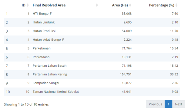
In this case, formerly, the unresolved cases cover an area of 89,656 ha (19.42%), and consist of 29 IDs (pixels?). After determining the desired planning unit type in the overlapping area, the analysis results show that these 29 pixels fall into 10 classes.
2.5 Theoretical Background
2.5.1 Model Description
The PUR module helps identify the location and extent of various overlapping area designations. These results can then be used as a basis for more open and directed discussions in the process of updating planning units.
2.5.2 Key Assumptions
2.5.3 Limitations
2.6 References
[ @article{dewi2015negotiation, title={Negotiation support tools to enhance multifunctioning landscapes}, author={Dewi, Sonya and Ekadinata, Andree and Indiarto, Dony and Nugraha, Alfa and van Noordwijk, Meine}, book={ Climate-Smart Landscapes: Multifunctionality in Practice }, pages={444}, year={2015}, publisher={ World Agroforestry Centre (ICRAF)} }]
